

Northeast Georgia is under a slight risk of severe thunderstorms Monday afternoon into Tuesday.
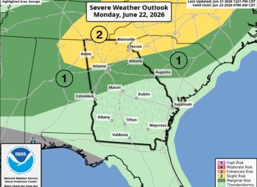
According to the National Weather Service (NWS), some storms could become strong to severe with gusts up to 60-mph. The forecast is after 4 p.m. Monday into the overnight hours of Tuesday.
The primary impact is expected to be downed trees and power lines, and an isolated tornado has not been ruled out. Localized flash flooding is also a concern.
The level two area is every part of northeast Georgia north of Barrow County, including all of Hall, Forsyth, Dawson, White, Habersham, Banks, Stephens, Rabun, Towns, Union, Lumpkin, Franklin, Pickens, Gilmer, and Fannin Counties.
Additionally, northern Jackson and Gwinnett Counties are also in the level two or "slight risk" area. Everything north of Macon is in the level one or "marginal risk" area.

Northeast Georgia History Center to hold special event for 1936 Tupelo-Gainesville tornado outbreak
6:00 pm ON June 21, 2026
Roadwork scheduled in Lumpkin County June 22-26
2:00 pm ON June 21, 2026